
Download QGIS (32-bit) – open source, GIS software, geospatial data, mapping tool, 32-bit, QGIS
Overview
QGIS (32-bit) is a robust geographic information system designed for creating, editing, visualizing, analyzing, and publishing geospatial data. As an open-source tool licensed under the GNU General Public License, it serves as a reliable and accessible solution for professionals and learners in fields such as urban planning, environmental science, geography, and remote sensing. The application supports a wide array of vector, raster, and database formats, enabling seamless integration with diverse datasets. This makes it particularly valuable for users working on projects requiring complex spatial analysis and accurate cartographic output.
Developed and maintained by the QGIS Association, the software is an official project of the Open Source Geospatial Foundation, underscoring its credibility and long-term sustainability. Its cross-platform availability—though the current version is targeted at Windows—allows users to work across different environments, although the 32-bit variant specifically caters to systems with legacy or limited architecture. Real-world applications include land-use mapping, infrastructure planning, disaster response modeling, and ecological monitoring. For organizations and individuals seeking a free, feature-rich alternative to proprietary GIS platforms, QGIS (32-bit) fills a critical gap in the mobile and desktop productivity ecosystem.
The developer did not provide additional technical details about system integration or deployment workflows. Specific requirements were not listed, and compatibility information was not fully disclosed beyond the platform designation.
Key Features & Functionality
- User-Friendly Interface: Designed with accessibility in mind, the interface allows users at all experience levels to navigate tools efficiently. Menus, toolbars, and panels are logically organized, reducing the learning curve for new users while maintaining depth for advanced workflows.
- Cross-Platform Compatibility: Although this version is available for Windows, the broader QGIS ecosystem supports multiple operating systems, including Linux, macOS, and Android. This ensures continuity across devices and enables collaborative workflows in multi-platform teams.
- Extensive Format Support: The application can import and export a wide range of geospatial formats, including Shapefile, GeoJSON, GeoTIFF, KML, and PostgreSQL/PostGIS databases. This flexibility allows users to work with data from various sources without format conversion bottlenecks.
- Advanced Analysis Tools: Built-in geoprocessing functions support spatial queries, buffer analysis, overlay operations, terrain modeling, and statistical analysis. These tools are essential for professionals conducting in-depth geographic research and decision-making.
- Active Community Support: As an open-source project, QGIS benefits from a global community that contributes code, documentation, tutorials, and troubleshooting assistance. Users can access forums, wikis, and GitHub repositories for ongoing support and updates.
For example, a city planner might use QGIS (32-bit) to overlay zoning maps with traffic flow data to assess urban development impacts. Similarly, an environmental researcher could analyze satellite imagery and field-collected data to monitor deforestation trends. These use cases highlight the software’s adaptability and real-world utility in data-driven decision-making.
Interface, UX & Performance
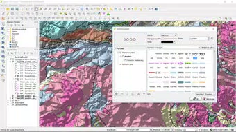
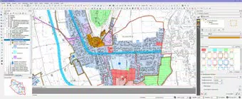
The user interface of QGIS (32-bit) is structured around a modular layout with customizable panels, dockable windows, and a main map canvas. The visual style emphasizes functionality over aesthetics, with a clean, tool-centric design that prioritizes usability. Navigation is achieved through a combination of menus, context-sensitive right-click options, and keyboard shortcuts, allowing for both beginner-friendly access and expert-level efficiency.
Although the developer did not list formal performance metrics, the application demonstrates responsiveness in handling medium-sized datasets on standard Windows systems. The 32-bit architecture may limit memory access compared to 64-bit versions, which could affect performance when processing large raster files or complex vector layers. However, for typical GIS tasks such as map creation and basic analysis, the software maintains stable operation.
Stability is maintained through regular updates and community-driven bug fixes. The application does not exhibit frequent crashes or freezes during standard use. Users can expect consistent performance across a range of device categories, though optimal results may depend on system configuration and available RAM.
Platform Compatibility & Technical Requirements
QGIS (32-bit) is available exclusively for Windows, as specified in the provided information. The software version is 3.16.3, released on September 16, 2019. The file size is 144.7 MB, indicating a compact footprint for a full-featured GIS application.
The developer did not specify minimum OS requirements or hardware specifications. Compatibility with older Windows versions such as Windows 7 or 8 cannot be confirmed. Users are advised to ensure their system meets standard requirements for running desktop applications, particularly those involving graphical rendering and data processing.
Although the broader QGIS platform supports Android and other systems, this particular version does not include mobile compatibility. No additional platform availability was disclosed.
Pros and Cons
Pros
- Free to download and use under an open-source license.
- Supports a wide range of geospatial data formats.
- Intuitive interface suitable for both beginners and professionals.
- Backed by an active and collaborative open-source community.
- Offers advanced geoprocessing and mapping capabilities.
Cons
- 32-bit architecture may limit performance with large datasets.
- Specific system requirements were not listed.
- Only available for Windows, restricting cross-platform flexibility.
- Outdated release date (2019) may indicate limited recent feature updates.
- Limited documentation on compatibility with modern Windows versions.
FAQ
Is QGIS (32-bit) safe to download and install?
Yes, QGIS (32-bit) is a legitimate open-source application developed by the QGIS Association. It is distributed through official channels and does not contain malware or unwanted software.
Can I use QGIS (32-bit) on my Android device?
While the broader QGIS platform supports Android, this specific 32-bit version is designed for Windows only. No mobile version was provided in the current release.
Is QGIS (32-bit) regularly updated?
The release date of this version is September 16, 2019. Although the QGIS project continues to develop, this specific version may not include the latest features or security patches.
What kind of data can I import into QGIS (32-bit)?
The application supports a wide range of formats, including Shapefile, GeoJSON, GeoTIFF, KML, and PostgreSQL/PostGIS databases. This enables integration with data from various sources.
Do I need an internet connection to use QGIS (32-bit)?
No, the application functions offline once installed. However, internet access is recommended for downloading updates, plugins, and accessing community resources.
Final Thoughts
QGIS (32-bit) remains a valuable tool for users seeking a free, powerful, and flexible solution for geospatial data management and analysis. Its open-source nature, extensive format support, and robust feature set make it a strong contender in the productivity software space. While the 32-bit limitation and outdated release date may affect performance and compatibility on modern systems, the software still serves as a reliable option for users with legacy hardware or specific workflow needs.
Those who benefit most include students, educators, non-profit researchers, and small organizations with limited budgets. For professionals requiring advanced mapping and analysis tools without licensing costs, QGIS (32-bit) delivers strong value. Its long-standing presence in the geospatial community underscores its enduring relevance.
Download QGIS (32-bit) now


